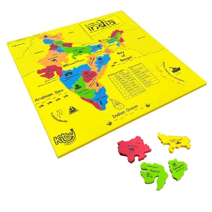
Imagimake: Mapology India With State Capitals –Learn Indian States Along With Capital- Fun Jigsaw Puzzle – Educational Toy For Kids Above 5 Years
Funskool - Play & Learn India Map Puzzles
Charts: India Map ( Wall Map) Wall Chart – Big Book
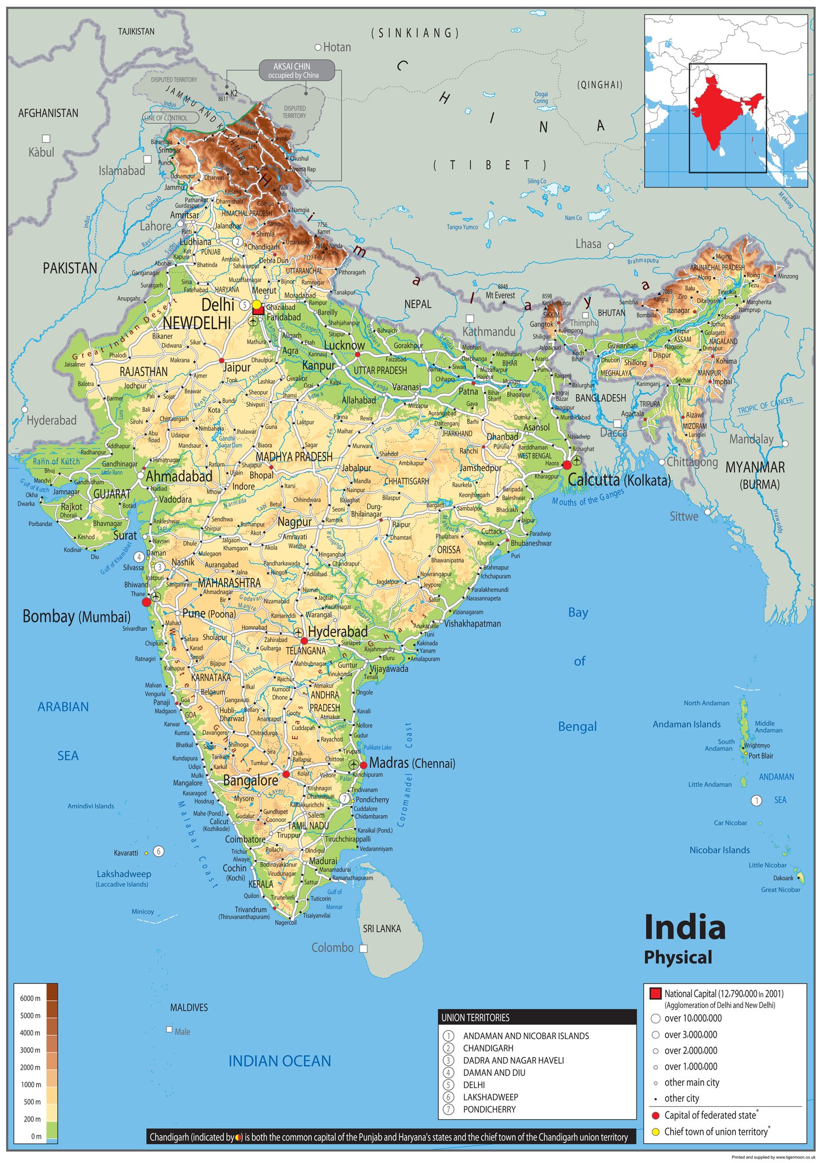
Physical Map of India - Size A2-59.4 x 42cm - Paper Laminated
Oxford School Atlas | 37th Edition |220+ Easy to Understand Maps with 120 Thematic Maps of India | NEP aligned
Physical Map of India - Size A1-59.4 x 84.1cm - Paper Laminated
India Travel Map (Periplus Travel Maps) (Periplus Travel Maps Country Map)
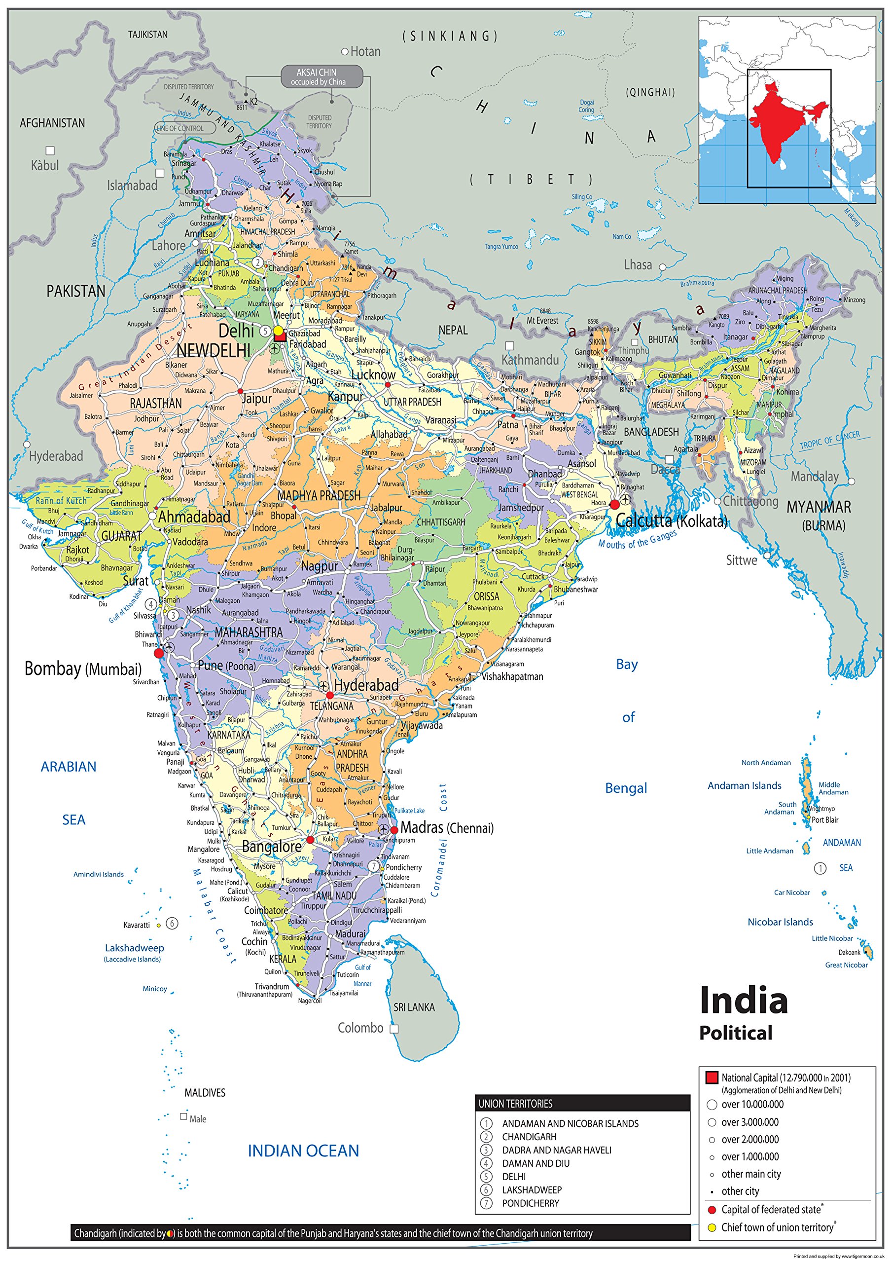
Political Map of India - Size A2-59.4 x 42cm - Paper Laminated
India South nel.map Goa-Bangalore-Chennai-Andaman: Including Andaman/Nicobar Islands, Lakshadweep. SPECIAL MAPS: Goa - Hampi Bazaar. CITY MAPS: ... - Cochin - Thiruvananthapuram (Trivandrum)
Lonely Planet India Planning Map
Imagimake: Mapology India- States of India- Play and Learn India Map in Puzzle- Jigsaw Puzzle- Educational Toy- for Boys & Girls
Imagimake Mapology India Map with Flash Card| Swipe & Reveal Card Game | Educational Toys for Kids 7+ Years | Kids Learning Toys | Puzzle Game for Kids 7 to 10 Years | Birthday Gift for Girls & Boys
Imagimake Mapology India with State Capitals - Educational Toy and Learning Aid for Boys and Girls - India Map Puzzle - Jigsaw Puzzle, 25 Pieces, Kids
India Northwest Map (National Geographic Adventure Map, 3013)
Lonely Planet India Planning Map
Gifts DelightLaminated 24x28 Poster: Political Map - Maps of India Detailed map of India in English Tourist map of India Road map of India
India South Map (National Geographic Adventure Map, 3014)
Lonely Planet India Planning Map Map – Folded Map, July 17, 2018
ImagimakeMapology India Map Puzzles - Geography for Kids - Learning & Educational Toys - Puzzles for Kids Ages 4-8 - Gift for 4, 5, 6, 7, 8 Year Old Boys & Girls
India Map: Travel Maps International Adventure Map (National Geographic Adventure Map)
Lonely Planet India Planning Map
Wonder House Books Political Map of India : Latest Map of India With The Two New Union Territories of Jammu & Kashmir And Ladakh (30 Inches X 20 Inches)
India Northwest Map: Travel Maps International Adventure Map (National Geographic Adventure Map)
1903 India Map - 11x14 Unframed Art Print - Great Wall Decor in This Highly Detailed Restored Reproduction Under $15
India Classic, Laminated: Wall Maps Countries & Regions Map – 1 August 2022
Gifts DelightLaminated 24x26 Poster: India Map Political, Map of India, Political Map of India with Cities, Online Map of India, Map
Creative’s Know India | Map Puzzles| Learning & Educational | Jigsaw Puzzles | Learning Games for Kids | Educational Puzzle Games | Geography Puzzles for Ages 7 & up
DAYONG Scratch Off Word Map, Scratch Off Map with Scratcher and Brush, 82x60CM Scratch Off Travel Poster, Travel Map Wall Art Gift for Outdoor Enthusiasts
National Geographic India Wall Map - Classic - Laminated (23.5 x 30.25 in) (National Geographic Reference Map) Map – August 1, 2022
Webby Wooden Educational India Political Map States Capital Learning, Board Puzzle for 4, 5, 6, 7, 8 Year Old Kids
EL FIGO Map of India Wooden Puzzle (15 Pieces) for Kids Age 3 & Above
Palmetto Posters 24x31 Laminated Poster: Large scale political and administrative map of india with roads railroads and major cities
India Map : Political | Laminated Both Sides | 70 x 100 cm ( Big Map )
Gifts DelightLaminated 24x28 Poster: Map of India
India Map Coloring Book: Political Maps Of Indian States & Union Territories
India Jumbo Country Map Magnet by Classic Magnets, Collectible Souvenirs Made in The USA
National Geographic: India Classic Wall Map - 23.5 x 30.25 inches - Art Quality Print
India & World Map ( Both Political & Physical ) with Constitution of India, Indian History, Indian Economy & Geographical Terms Chart | Set Of 8 | Useful for UPSC and other competitive exam preparation | by Hivex Publication Product Bundle – Wall Map, 30 December 2021
ImagimakeMapology India Flash Cards | Learn States Along with 450+ Fun Facts |Swipe & Reveal Card Game | Birthday Gift for Girls & Boys Ages 8,9,10,11,12
India Map (100 x 140 cm) Laminated (Big Map) -With New Union Territories of Jammu & Kashmir and Ladakh Multicolour
India Northeast Map (National Geographic Adventure Map, 3012) Map – Folded Map, January 1, 2020
India & World Map ( Both Political & Physical ) with Constitution of India Chart, History of India Chart & Geography Terms Chart | Set Of 7 | Useful for UPSC and other exams | By VCP Product Bundle – Folded Map, 1 January 2021
ImagimakeMapology India Map Puzzles - Includes State Capitals - Geography for Kids - Learning & Educational Toys for Kids 5-7 - Gift for 5, 6, 7, 8 & 9 Year Old Boys & Girls
Imagimake: Mapology India and World Maps with Capitals - Learn Capitals and Country Flags - Educational Toy for Kids Above 5 Years, Multicolor
Imagimake Mapology India Map Puzzles - Geography for Kids - Learning & Educational Toys - Puzzles for Kids Ages 4-8 - Gift for 4, 5, 6, 7, 8 Year Old Boys & Girls
India Classic, Tubed: Wall Maps Countries & Regions Map – 2 August 2012
BIG - 100 IndiaN POLITICAL OUTLINE MAP FOR SCHOOL| India Political Map: Clear Outline for School Reference Paperback – 18 June 2024
India West Delhi-Mumbai-Bomba
TOYSCAPE Foam India Map Puzzle | Learn Indian States and Capitals, Geography for Kids, Learning & Educational Toys | 30 Pieces Puzzles for Kids Ages 4+
Political Map of India - Size A1-59.4 x 84.1cm - Paper Laminated
EL FIGO Map of India Wooden Puzzle (15 Pieces) for Kids Age 3 & Above
India West Delhi-Mumbai-Bomba
India South Map: Travel Maps International Adventure Map (National Geographic Adventure Map) Map – Folded Map, 1 Jan. 2020
Wooden India Map Puzzle for Kids with States, Their Capitals, 18 Pieces with Knobs | Educational Wooden Puzzle Games for Boys and Girls | Map of India Puzzle for Kids | Jigsaw Puzzle Games for Kids
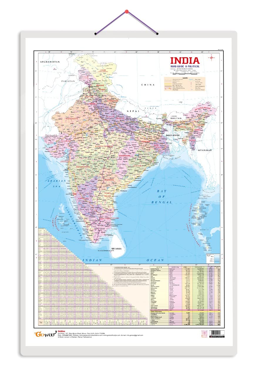
Indian Road Guide & Political Map Charts with Big font and Dust resistant Lamination | 300 GSM Recyclable Charts
India and World Political Map - LAMINATED | Size - 70×100cm | India Map | World Map Unknown Binding – 30 December 2021
Political Map of India - Size A0-84.1 x 118.9cm - Paper Laminated
Funskool - Play & Learn India Toy Map, Educational, 104 Pieces, Puzzle, For 6 year Old kids And Above, Multi Color
India East Calcutta (Nelles Maps)
Classic Magnets Made with Pride in the USA India Jumbo Country Map by Collectible Souvenirs